
Thingvellir National Park
It’s no secret that Iceland is at the top of everyone’s bucket list right now. Waterfalls, hot pools, out-of-this-world jaw dropping landscapes – what’s there not to love, right? It’s no wonder that this land of Fire and Ice serves as the backdrop for so many Games of Throne scenes. As an aspiring photographer, I couldn’t help feeling excited for all the Instagram-worthy spots around Iceland. After taking over EIGHT THOUSAND photos (I know, I have a problem!) I can tell you that it’s almost impossible to take a bad picture – this country is just that photogenic. Here is a list of the 25 most Instagrammable places in Iceland to get you even more excited, because it’s never too early to start planning. I’ve also included their GPS coordinates so you can find it easily.
To plan your Iceland trip, click here for the complete guide and 11-day itinerary.
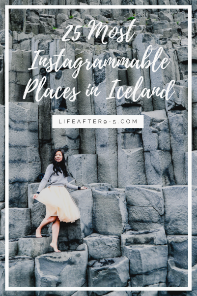
1. Ingjaldshóll

Running around the empty street in Ingjaldshóll
Ingjaldshóll is an old church in the Snæfellsnes Peninsula that can be traced back to the 10th century. The pretty church sits at the end of a road that can be seen from miles around. In the Spring, the surrounding fields are filled with wild purple flowers, that combined with the snow-capped mountain backdrop, make this one of the most photogenic sites.
GPS Coordinates: 64.908175, -23.852889
2. Saxhóll
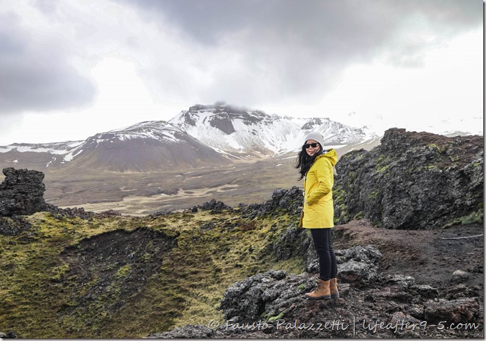
Standing at the top of Saxhóll
If you’re driving around the Snæfellsnes Peninsula, make sure to add Saxhóll to your list of places to visit. This is a crater that erupted 3-4 thousand years ago. This interesting stop was not even on our radar, but we saw it on our way to Lóndrangar and had to pull over. For the best views, pull into the parking lot and climb up the stairs to the top. From the rim of the crater you can see the rugged landscape stretched out for miles.
GPS Coordinates: 64.851668, -23.926522
3. Lóndrangar

The stunning cliff side at Lóndrangar
The Lóndrangar are a pair of rock pinnacles located deep in Snæfellsjökull National Park. The sea stacks rising from the ocean look like castles from afar. The dramatic cliff surrounded by soft green moss is quite a sight to behold. Standing at the edge, you can see the birds gliding gracefully in the wind as the powerful waves crash onto the rocks.
GPS Coordinates: 64.732683, -23.784609
4. Búðakirkja

Black Church in Iceland
In the hamlet of Búðir, in the southern coast of the Snæfellsnes peninsula, there’s a tiny village with just a boutique hotel and a wooden black church called Búðakirkja. This 19th century church sits on a lava field overgrown with grassy moss. The lonesome church stands out in this dreamy landscape. Visitors can walk all the way to the coastline, but since its Instagram notoriety, people mostly venture this far only to see this unique church.
GPS Coordinates: 64.821930, -23.384507
5. Reynisfjara

Basalt columns at Reynisfjara black beach
Reynisfjara is the most scenic of Iceland’s beaches with its volcanic black sand, enormous basalt columns, and sea stacks. The wild Atlantic Ocean with its powerful waves crashing ashore further adds to the natural beauty of this place. It’s not hard to see why this is one of South Iceland’s most popular stops. Due to its popularity, the beach is always crowded, if you want photos without other people, make sure you get there before 8 am.
GPS Coordinates: 63.406074, -19.051964
6. Sólheimasandur Plane Crash

Sólheimasandur plane wreck
Sólheimasandur is the famous site where a DC-3 plane crash-landed in 1973, luckily all passengers survived. The stark contrast between the surreal terrain and the hulking metal wreck makes this a photographer’s dream. Which explains why it’s a major attraction in Iceland. To avoid the crowd, make sure you arrive before 9 am. Getting there can be done easily on foot. The walk takes about 45 minutes each way on a nice day.
GPS Coordinates: 63.490749, -19.362814
7. Loftsalahellir Cave

Loftsalahellir Cave overlooking Dyrhólaey
Located near Vik, Loftsalahellir Cave is a cool place to explore and capture an Instagram worthy shot. From this vantage point, you can see the surrounding landscape including the Dyrhólaey archway. Its unusual opening makes the cave a favorite spot for photographers. Even though its popularity has increased in recent years due to Instagram, it still remains relatively unknown. To get up to the cave, you have to scramble up a small hill. Be careful however, the path can be slippery on a wet day.
GPS Coordinates: 63.421944, -19.151389
8. Vík í Mýrdal Church

Vík í Mýrdal Church overlooking Vik
For the best view of Vik and the rugged southernmost point of Iceland, go to the parking lot at top of the hill behind Vík í Mýrdal Church. From this vantage point, you’ll see the iconic red roof church, colorful houses, and the striking Reynisdrangar stacks in the distance. It’s even more beautiful in the spring when the church is surrounded by wild flowers.
GPS Coordinates: 63.421332, -19.000249
9. Jökulsárlón
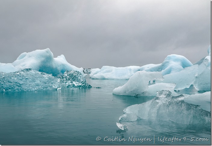
Iceberg floating in Jokulsarlon Glacier Lagoon
Jokulsarlon Glacier Lagoon is filled with icebergs broken free from Breiðamerkurjökull Glacier drifting languidly before being pushed out to sea. The bright turquoise ice floats look like sleeping giants, sculpted over the years by wind and water. This is undoubtedly one of the most beautiful places in Iceland. I could spend hours here with my camera!
GPS Coordinates: 64.051521, -16.180870
10. Svínafellsjökull Glacier Tongue

Looking out at the Svínafellsjökull glacier tongue
Svínafellsjökull is a tongue of the famous Vatnajökull glacier, the largest ice cap in Europe. It is a massive and a magnificent sight to behold. At the base, you’ll see chunks of ice floating in a milky brown lake, like a big giant cup of iced cappuccino. Climb up to the top for a full view of the glacier. Aside from being the best spot for photos, there is hardly anyone up there, so you can sit back and admire the raw beauty of Iceland. If you sit long enough you might even see or hear the ice calving.
GPS Coordinates: 64.015120, -16.795937
11. Stokksnes
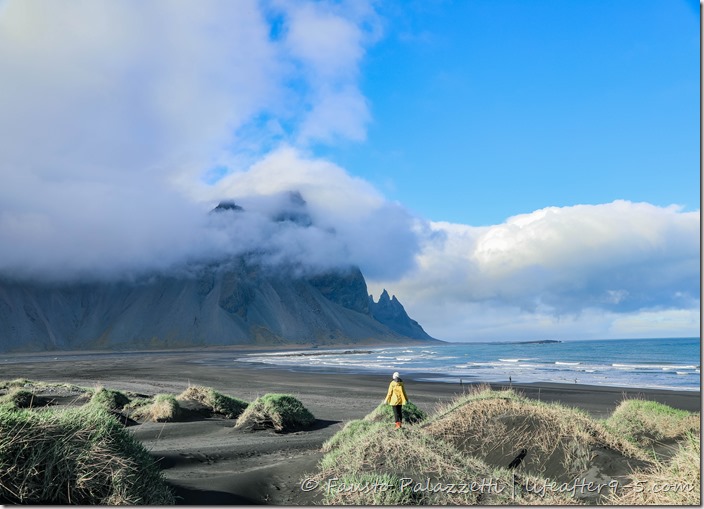
Standing on the grassy hills at Stokksnes
For the best views of the Vestrahorn mountains looming over the black sand beach, make sure you stop by Stokksnes in Eastern Iceland. The serene landscape and unbelievable views will leave you completely in awe. You can’t help but feel small in this majestic setting. This was hands down, our favorite stop of the trip. The best part was that we had the entire place to ourselves to frolic around the the deserted beach and enjoy the natural scenery. For the best photos, climb up to the grassy hills for the panoramic views.
GPS Coordinates: 64.244222, -14.964859
12. Borgarfjarðarhöfn
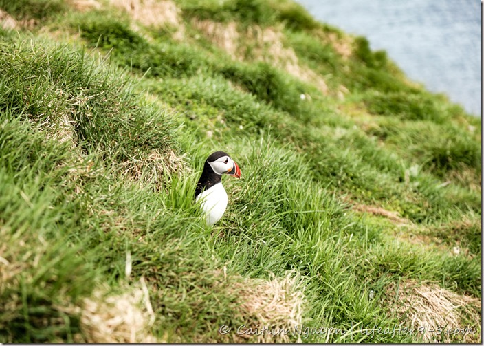
Borgarfjarðarhöfn is a small protected island in east Iceland, home to thousands of puffins
The cute puffins are hard to resist and on the top of the list of things I wanted to see in Iceland. The challenge is finding them close enough to take a photo without having to use a big zoom lens. So when I heard about Borgarfjarðarhöfn, a small protected island in east Iceland and home to thousands of puffins, I knew I had to visit even though it was a 2 hour detour. Here, the puffins are so close, I felt like I could almost reach out to touch them.
GPS Coordinates: 65.542155, -13.754621
13. Krafla Viti Crater

Looking down at Viti crater
The Viti Crater looks like something out of this world. It was formed back in the 18th century from an eruption of steam, but now sits dormant. The brown crater is filled with pretty turquoise water creating a striking juxtaposition. For the most Instagrammable photo, hike around the rim to get an aerial shot or climb down to the lake for an up-close photo with the water.
GPS Coordinates: 65.717894, -16.754419
14. Námafjall Hverir

Námafjall Hverir geothermal field
In Iceland you’ll find many geothermal fields, but none as impressive as Námafjall Hverir. The earthy red terrain is covered with hot springs, bubbling mud pits and bellowing smoke coming out from the vents creating a very distinctive landscape. Leaving the car, we were greeted with a strong sulfur smell that permeated our clothes and skin – but the smell was quickly forgotten as we took in the otherworldly surroundings.
GPS Coordinates: 65.641818, -16.809763
15. Dimmuborgir

Rock formation at Dimmuborgir
The massive area of Dimmuborgir was formed over 2000 years ago during a volcanic eruption. Today, the resulting caves and lava formations make you feel like you wandered into a world of fairy-tales where Yule Lads exist. In Icelandic folktales, Yule Lads were portrayed as mischievous trolls who live in these rock caves and come out in the winter to wreak havoc in the nights leading up to Christmas. The Yule Lads are Iceland’s version of Santa Claus.
GPS Coordinates: 65.591235, -16.911101
16. Skútustaðagígar

View of Myvatn lake from Skútustaðagígar pseudocraters
On the shores of Lake Myvatn, you’ll find these amazing pseudocraters that formed when boiling hot lava flowed over the wetlands triggering steam explosions. You can walk around the rims of these unique geological formations for the perfect view of the Myvatn from above.
GPS Coordinates: 65.571029, -17.034769
17. Þingvellir National Park

Rift valley at Þingvellir National Park
Þingvellir is a unique location where the rift valley was created by the separation of the North American and Eurasian tectonic plates. It’s the only place on earth where you can see tectonic plates above ground and even walk in the giant fissures between the rocky cliffs. Aside from the geological phenomenon, Þingvellir is also the site of Iceland’s old parliament, established in 930 AD. This historical area played an important role in Iceland’s heritage.
GPS Coordinates: 64.255968, -21.129894
18. Strokkur Geysir

Strokkur geyser exploding out of the ground
Strokkur Geysir is high on every tourist’s list and a must-stop in the Golden Circle tour. After the great Geysir, which has been dormant since 1916, Strokkur is the biggest geyser in Iceland shooting water up to 100 feet into the air. It goes off like clockwork every 5-10 minutes, so make sure you have your boomerang ready to capture the surge of water that erupts out of the ground. You can tell that it is about to go off when the water starts bubbling. If you time it just right, you will see the turquoise water underneath the billowing cloud of steam.
GPS Coordinates: 64.312807, -20.300740
19. Hallgrímskirkja

Impressive Hallgrímskirkja in Reykjavik
The church, which took 41 years to complete, was built in tribute to Hallgrímur Pétursson, one of Iceland’s best known poets. This is the largest church in Iceland and also the sixth tallest building in country. The mountain-like tower can be seen from almost anywhere in the city. The pillar design was inspired by the basalt columns, mountains, and glaciers of Iceland’s landscape. For the best view of the city, head up to the viewing room at the top.
GPS Coordinates: 64.141832, -21.926723
20. Reykjavik

View of Reykjavik from top of Hallgrímskirkja
Unlike other capital cities filled with skyscrapers, Reykjavik is dotted with quaint multi-color houses surrounded by water and mountains. A 360-degree panorama view of this picturesque city can be seen from the top of Hallgrimkskirkja.
GPS Coordinates: 64.141832, -21.926723
21. Harpa Concert Hall

Standing inside Harpa Concert Hall
Harpa Concert Hall is one of Reykjavik’s most recognizable landmarks. Its distinctive shape and design looks like a massive iceberg from the outside and an irridescent honeycomb on the inside. The open airy design showcases the basalt-shaped glass prisms that sparkle and change color under the sunlight. The colorful façade makes a stunning backdrop for any photo.
GPS Coordinates: 64.150596, -21.932854
22. Sun Voyager

Sun Voyager under stormy sky
Walking along the harbor from the Harpa Concert Hall, you’ll come across a shiny skeletal ship. This is the famous steel sculpture by Jón Gunnar Árnason, one of the many art installations along Reykjavik’s scenic waterfront. This dream boat is a tribute to the sun. The sculpture is perfectly framed by the surrounding water and distant mountains, creating a stunning photo.
GPS Coordinates: 64.147727, -21.922318
23. Gardur
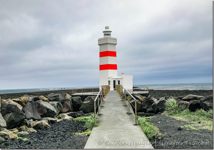
Lighthouse at Gardur
There are many interesting lighthouses on the southern coastline of Iceland, but what made this particular one stand out is the pop of color against the black background. Located at the very tip of the peninsula in the tiny coastal village of Gardur, the lighthouse provides magnificent views of the sea. This diverse area is also known as a birder’s paradise, a breeding ground for many northern Atlantic seabirds.
GPS Coordinates: 64.083036, -22.693254
24. Hvalsneskirkja

Hvalsneskirkja sitting in a lush green field
Colorful fishing villages line the coast of the Reykjanes Peninsula, each with their own distinctive churches. While driving, we came across this lovely black stone church sitting on a lush green field and had to stop for a quick photo. Unfortunately, the weather was not cooperating and rain splattered water all over my lens so we had to come back 3 times to get a usable shot.
GPS Coordinates: 63.990004, -22.735819
25. Icelandic Horses

Playing with Icelandic horses
You can’t be in Iceland without a photo with Icelandic horses, it’s impossible because they are just so handsome! We saw a few on the side of the road and had to pull over. They were quite friendly and more than happy to have people fawning over them. I’m not going to lie, I am jealous of that thick luscious mane that should be featured in a shampoo commercial. Aside from looking handsome, these horses are quite special and only bred in Iceland. They are smaller than regular horses, but to make up for their diminutive size, they are hardy and sure footed across rough terrain.
GPS Coordinates: various
Like it? Pin it!



Most of our pictures in iceland , make me feel really want to visit this country
LikeLike
You should have come with us then!
LikeLike
Thanks so much for this post! I’m heading to Iceland in January so hope to see plenty of these spots!
LikeLike
That’s so exciting, You’ll get to see the northern lights at that time, we didn’t catch it the first time we were there in November.
LikeLike
I couldn’t agree more! I loved taking photos in Iceland. Although it would be nice if the sun came out more often for better pics! 😛
LikeLike
Yes!! That was my thoughts exactly. It rained like almost every day we were there otherwise it’s overcast sky. So so my pictures are moody.
LikeLike
Iceland looks truly stunning and is so high on my bucket list ! Well done on those beautiful pictures 😀
LikeLike
Thank you so much Emma! The Icelandic landscape is truly out of this world.
LikeLike
Ahhh such a great guide! I’m always on the hunt for gps coordinates of photography spots! Super helpful! Thank you I’m dying to visit Iceland! Beautiful photos!
LikeLike
Thank you so much! I figured it’ll help people find places easier, since some of these places are not found easily on the map.
LikeLike
Wow! You’ve chosen some very exceptional and mesmerizing places in charming Iceland! I can’t stop looking at your pictures!
LikeLike
Thank you so much! Iceland was very stunning, so it wasn’t hard to find these places
LikeLike
Pingback: Trip Report: Iceland | life after 9to5
Pingback: Iceland in 11 Days: The Ultimate Road Trip Itinerary and Guide | life after 9to5
Great post! Inspiring! We Love Iceland – and have never been there! Huge Sigur Ròs Fans, Travel Addicts and Explorers so in a near future..! Thanks for the tips!
LikeLike
Iceland was such an incredible experience!
LikeLike
Wow ! Your pictures are really amazing. Very beautiful and inspiring shots. Really enjoyed the post, thanks for sharing. I recently went there for the Golden cirlce tour with my family in sept/oct, really cold but probably the best trips I’ve ever been on. Here a short video of some of the places we visited.
LikeLike
Thank you so much for your kind words! Was that your first time in Iceland? It’s such a beautiful country.
LikeLike
Such beautiful pictures! Heading to Iceland in two weeks and we sure are happy to have come across your page. Thank you for such awesome insight 🙂
LikeLiked by 1 person
I hope you’ll have a great trip! Iceland is so beautiful.
LikeLike