After a few days in Wanaka, we continued our journey onwards to Mount Cook, the highest peak in Australasia at 3,755 metres. Aoraki Mount Cook National Park is home to many other towering peaks as well as the longest glaciers in New Zealand. According to legends, Aoraki and his three brothers, the sons of the Sky Father, had their canoe overturned on a reef while on a sea voyage. When the brothers climbed on top of their canoe, the freezing south wind turned them to stone. The canoe became the South Island (Te Waka o Aoraki) and Aoraki and his brothers became the peaks of the Southern Alps.

To get to Mount Cook from Wanaka we headed North on State Highway 8 via the Lindis Pass. The actual pass crosses a saddle between the valleys of the Lindis and Ahuriri Rivers. Golden tussock-covered mountains stand tall on either side of the pass that winds through the valley floor. The landscape is barren with no signs of civilization, but incredibly gorgeous. You can pull over at the Summit Lookout at the top of the pass to take pictures of the area.


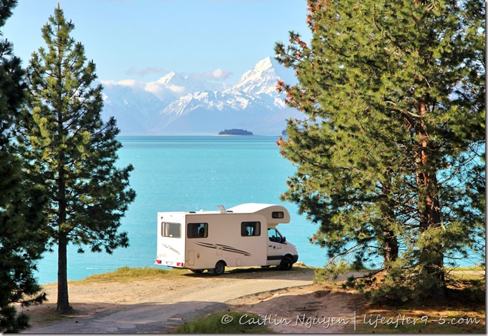
The Pines was hands down, our favorite place to camp during the entire trip, and it was FREE! This freedom camping site is located on a prime spot at the edge of Lake Pukaki with amazing views of Aoraki/Mount Cook. Lake Pukaki is the largest of the three alpine lakes in the area, its water the most striking color I’ve ever seen. At first glance, it looks Photoshopped, but I assure you it isn’t. The intense milky-turquoise color is a result of the fine rock-flour (ground by glaciers) that hardens at the bottom of the lake into a white cement base which helps reflect the sky creating a magnificent and unforgettable combination. On a clear day, you can easily see Mt. Cook at the other end of the lake looming in the distance.


The camp site is located on Hayman Rd, just off of Highway 8. Once you’re on Hayman Rd, keep an eye out for small dirt roads that take you down to the edge of the lake. Drive along the road until you find a spot that you like and stake your claim for the night. We found that the site near the Highway 8 junction has the best views of the mountains, but you can keep driving in for another mile or so. A little further down you’ll find a location with a long drop toilet that still has a nice view of the lake. If you see a power plant with red pipes, you’ve gone too far. These sites are very basic and have no facilities and drinking water. Amazingly, we had perfect cell phone reception while camping here and were able to access our internet.


We got there early on both days, and found some prime spots right by the water. We set up camp, pulled out our bean bag chairs, and kicked back with some beer and ice cream while enjoying the view. After dinner, we went for a walk by the lake to check out the water, but it was ice cold, and not suitable for swimming. An old tree stump hanging over a cliff with its roots half exposed made the perfect chair, and was officially my favorite place to sit and enjoy my morning cup of tea. There were some sand flies around, but that’s par for the course in New Zealand.

Make sure to only camp here if your car is self-contained certified. If you don’t know what that is, make sure you read our earlier post about freedom camping.


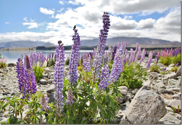
Lake Tekapo is the second-largest of three parallel Alpine lakes that run north to south along the northern edge of the Mackenzie Basin. It is located about a 40 minute drive from Lake Pukaki. Even though it is a bit out of the way, it was totally worth it because the setting is every photographer’s dream with blue turquoise water framed by snow-capped mountains. Every year from mid-November to December, the beauty of the lake is further enhanced by an explosion of colorful lupins, a flower that grows wild in this area, attracting visitors from around the world.


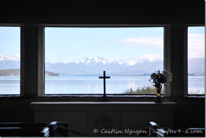
On the shores of the lake, atop a hill overlooking the field of flowers, you’ll find the beautiful Church of the Good Shepherd. It was built in 1935 for the pioneer families of the Mackenzie district and is still used as a place of worship today. The small church features an altar window that perfectly frames the stunning views of the Southern Alps beyond the lake. It is probably one of the most popular photo spots for visitors in New Zealand. There are nonstop busloads of tourists being dropped off to take a quick snap and then rush off to the next destination on their schedule. If you’re lucky, you’ll also see a few couples taking their wedding photos at this lovely spot.


On our second day, we headed over to Aoraki/Mt Cook . To get there, you just have to turn off of Highway 8 onto Highway 80 , following the length of the magnificent Lake Pukaki all the way to Aoraki/Mt Cook Village. The scenic 55 km drive takes about 40-50 minutes. This is hands down the most picturesque road in all of New Zealand. It’s the perfect setting for the most epic road picture with the towering mountains looming over the highway. I made Fausto stop a few times so I can take pictures. The best spot to take a photo of the mountains by the winding road is at Peter’s Lookout at the top of the drive. If you want to stop along the way, make sure to find a place where you can pull the car over safely.


Mount Cook Village, located 12 km from the base of the mountain, is pretty small with a population of less than 500 people. This village is the base camp for anyone who comes to enjoy the alpine activities in the area. Another mile in is the White Horse Hill parking area, the starting point of the various short walks. This also doubles as a DOC campground with basic facilities and flush toilets.


New Zealand is a country that inspires you to leave the city and venture out into the great wilderness. Rugged mountains, picturesque shorelines, and rolling hills are all around you, and all you have to do is head out to one of the well maintained trails to appreciate this magnificent landscape. Hooker Valley Track is one of the most popular short hikes in New Zealand with epic mountain views, glacial lakes, and floating icebergs. The 5-kilometer return walking track takes 3-4 hours to complete, and is considered ‘easy’ by New Zealand standards and suitable for people of all ages. On a sunny day, it can get very hot because there is no shade to protect you from the blazing sun, so make sure to bring lots of sunblock and water for the duration of the walk.


The path starts at White Horse Hill campground and carpark, taking you across the Hooker River into the Hooker Valley and ending at the glacial lake at the base of Aoraki/Mount Cook. The wide gravel trail weaves along the river and passes close to the Alpine Memorial and Freda’s Rock before arriving at the Lower Hooker Bridge, the first of three swing bridges. On either side of the path are stacked boulders and rocks that have fallen down from the nearby mountains, and now completely covered in moss. Prickly bushes and wild vegetation grow in abundance and give off a sweet smell. In the Spring, keep an eye out for the New Zealand buttercup, a delicate white flower with a yellow center, standing out against the moss and thorny trees.

We continued at an easy pace over the rolling hills and valleys. After another 20 minutes, we came to the Hooker Bluff Bridge. Once we crossed the second bridge, the vegetation changed to a wider valley floor covered with golden tussock. Looking up you’ll see little waterfalls and rock scree down the side of the mountain.


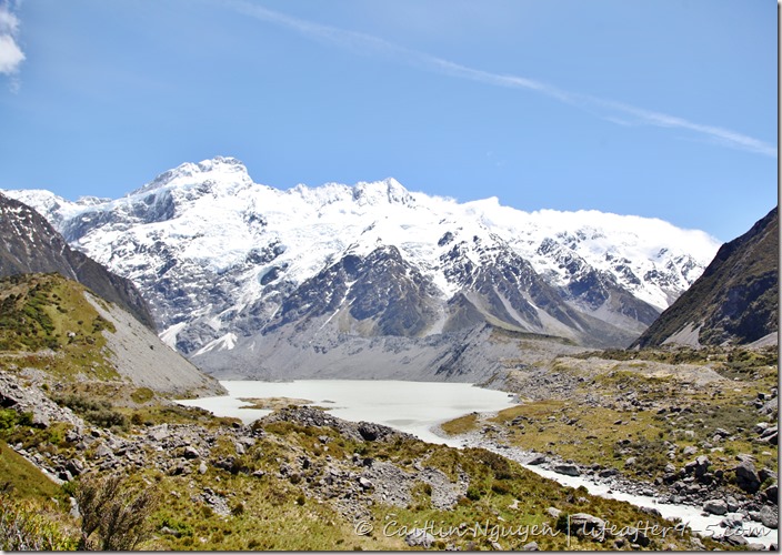
The third swing bridge took us to the source of the Hooker River. Soon, the gravel track gave way to a wooden boardwalk that wound around a flat valley, the location of the iconic photo of Hooker Valley. After a short scramble up the hill of moraine, we got to the Hooker Lake at the base of the mountain. This is the ending point of the track and also a great place for a break and some lunch. There is a picnic bench at the top, or you can walk down to the water.


The lake, filled with milky glacial water, floating icebergs, and backdropped by the looming Southern Alps was the setting for our lunch that day. We couldn’t resist soaking our aching feet in the water, but quickly found to our dismay that it was devastatingly cold. The ice cold lake water is filled from the melting glaciers. Just a few seconds in the water and I couldn’t feel my toes! After our long lunch break, we headed back to the car park. The walk back is slightly faster because I finally got used to running down hills.

Information Round-up:
- Distance: 200km from Wanaka to Mount Cook
- #Nights: 2
- Accommodation: Freedom Camping on Hayman Rd

Thank you for the wonderful post! Your pictures are a breath of fresh air! I hope that some day I will head to New Zealand, too!
Happy travels,
Moni
LikeLiked by 1 person
Thank you so much! New Zealand was amazing and gorgeous. I hope you’ll go one day as well. I can not recommend it enough.
LikeLiked by 1 person
Beautiful pictures! May I know when were you there to see the lupins (date) ? I’m planning a trip from Nov 18 onwards and visiting lake takepo on Nov 20. Was wondering if it’s too early to see the bloom.
LikeLiked by 1 person
Thank you! We were in New Zealand mid November, since we drive down from the north island, it probably take about 1-1.5 weeks to get to Mount Cook. So I would say end of November. I think November 20th should be ok, but if you’re worried I would wait another few days.
LikeLike